• ROMARCH: Online Coins of the Roman Empire, updated

    OCRE – Online Database of Coinage of the Roman Empire becomes Bigger, Multi-Contributor and Multi-Lingual

    In collaboration with New York University’s Institute for the Study of the Ancient World, the American Numismatic Society (ANS) is pleased to announce the release of a new version of OCRE (Online Coins of the Roman Empire) (numismatics.org/ocre/). The OCRE project is creating a revolutionary new tool designed to help in the identification, cataloguing, and research of the rich and varied coinage of the Roman Empire. It aims to provide a comprehensive online resource encompassing every known Roman Imperial coin type. The end result will be:

    •A database of 50,000 coin types
    •A resource that collectors can use to identify their coins, estimate their rarity, and discover unknown varieties.
    •An online reference tool for researchers to help in new research on this important series.
    •Easy to use, downloadable catalogue entries for the coinage of every Roman Emperor from Augustus in 31 BC, until the death of Zeno in AD 491.

    The new version of the tool contains important new improvements.

    Continue reading

  • ROMARCH: Barrington Atlas of the Greek and Roman World iPad app; Review

    20131031-075153.jpg

    Barrington Atlas App splash screen

    Princeton University Press has launched its iPad app version of the Barrington Atlas of the Greek and Roman World, as we noted here on Oct. 31. The app has been made available for $19.95 on iTunes. The Barrington Facebook page includes recent news and reviews about the release. Princeton provided a copy of the app for this review. Testing was done on a 4th-generation 128 GB iPad running iOS 7.0.4 after a clean restart.

    When the print version of the Barrington Atlas was published in 2000, the fruit of a multiyear international collaboration, it redressed a problem that had bedeviled the latter 20th-century: a lack of up-to-date, accurate, and visually informative/attractive (yes, I link those two attributes) maps for the classical world. Murray’s Small Classical Atlas, a short but distinguished accomplishment of Victorian cartography popular in schools, had seen its last update in 1917 (though reprints appeared through the 1950s).

    Hammond’s 1981 Atlas, from eBay

    The efforts of van der Heyden and Scullard (1962) and Hammond (1981) were useful as references, but their visual qualities (too few maps, and those reduced to atopographic colored line-drawings in the former; sepia monochrome in the latter) left much to be desired. The Facts-on-File Cultural Atlases released from 1980-1990 (“Greek World,” “Roman World,” “Egypt,” and “Mesopotamia and the ancient Near East”) were examples of the encyclopedia-style that prevailed in that decade, with lots of insets, photos, short descriptions, timelines and essays — an integrated approach that had many merits, but which were ultimately limited in sheer cartographic utility.

    Continue reading

  • Translating Pliny’s letters about Vesuvius, pt. 5. The Hero Embarks

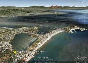
    Misenum2VesuviusGoogleE2

    Relative location of Vesuvius compared to the naval base at Misenum (inner and outer harbors visible at lower center). Based on GoogleEarth.

    6.16.7-10: The Hero Embarks

    This post belongs to a serialized translation and commentary of Pliny the Younger’s letters (6.16 and 6.20) to the historian Tacitus about the eruption of Mount Vesuvius in AD 79. This is the third installment for letter 6.16.

    The Younger Pliny has just unfolded a detailed description of the volcanic cloud that was first spotted by his mother around noon. (Note that this just provides a terminus ante quem for the initial explosion, but because of the explosive nature of ‘Plinian eruptions’, it is unlikely to have begun too long before Plinia noticed it.) Pliny is working from three sources: his memory, notes he took shortly after the event, and conversations with other people after the eruption (as he says later in section 22 of this letter).

    As the crater of Vesuvius is about 30 km. away from Misenum by direct line of sight, the Elder Pliny, his curiosity alight, decides to have a closer look. It is perhaps 2 or 3 in the afternoon (we don’t know how long Pliny took with his bath, his lunch, and his climb to a vantage point). There was as yet no sense of urgency, but that was about to change. Continue reading

  • Translating Pliny’s letters about Vesuvius, pt. 4. A Strange Cloud

    VesuvioVintagePostcard

    Strange Cloud: non alia magis arbor quam pinus (vintage postcard from Naples)

    6.16.4-6: A Strange Cloud

    This post belongs to a serialized translation and commentary of Pliny the Younger’s letters (6.16 and 6.20) to the historian Tacitus about the eruption of Mount Vesuvius in AD 79. This is the second installment for letter 6.16.

    The Younger Pliny now begins the tale that Tacitus has asked him to share. It is critical to remember that the real subject of, and reason for, these letters, is to honor the life and memory of the Elder Pliny–not to describe a volcanic eruption and its effects–though it was the latter that the Elder Pliny was interested in recording that day, as we will see later on.

    This post will also consider the date of the eruption in some detail.

    4 Erat Miseni classemque imperio praesens regebat. Nonum kal. Septembres hora fere septima mater mea indicat ei adparere nubem inusitata et magnitudine et specie. 

    4 He (Elder Pliny) was at Misenum and he was in command of the fleet. On the ninth day before the first of September at about the seventh hour, my mother indicates to him that a cloud of unusual size and shape is appearing. Continue reading