
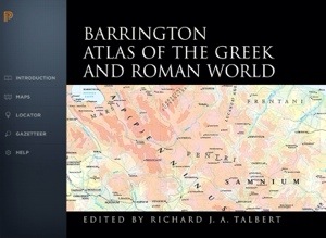
Barrington Atlas App splash screen
Princeton University Press has launched its iPad app version of the Barrington Atlas of the Greek and Roman World, as we noted here on Oct. 31. The app has been made available for $19.95 on iTunes. The Barrington Facebook page includes recent news and reviews about the release. Princeton provided a copy of the app for this review. Testing was done on a 4th-generation 128 GB iPad running iOS 7.0.4 after a clean restart.
When the print version of the Barrington Atlas was published in 2000, the fruit of a multiyear international collaboration, it redressed a problem that had bedeviled the latter 20th-century: a lack of up-to-date, accurate, and visually informative/attractive (yes, I link those two attributes) maps for the classical world. Murray’s Small Classical Atlas, a short but distinguished accomplishment of Victorian cartography popular in schools, had seen its last update in 1917 (though reprints appeared through the 1950s).

Hammond’s 1981 Atlas, from eBay
The efforts of van der Heyden and Scullard (1962) and Hammond (1981) were useful as references, but their visual qualities (too few maps, and those reduced to atopographic colored line-drawings in the former; sepia monochrome in the latter) left much to be desired. The Facts-on-File Cultural Atlases released from 1980-1990 (“Greek World,” “Roman World,” “Egypt,” and “Mesopotamia and the ancient Near East”) were examples of the encyclopedia-style that prevailed in that decade, with lots of insets, photos, short descriptions, timelines and essays — an integrated approach that had many merits, but which were ultimately limited in sheer cartographic utility.
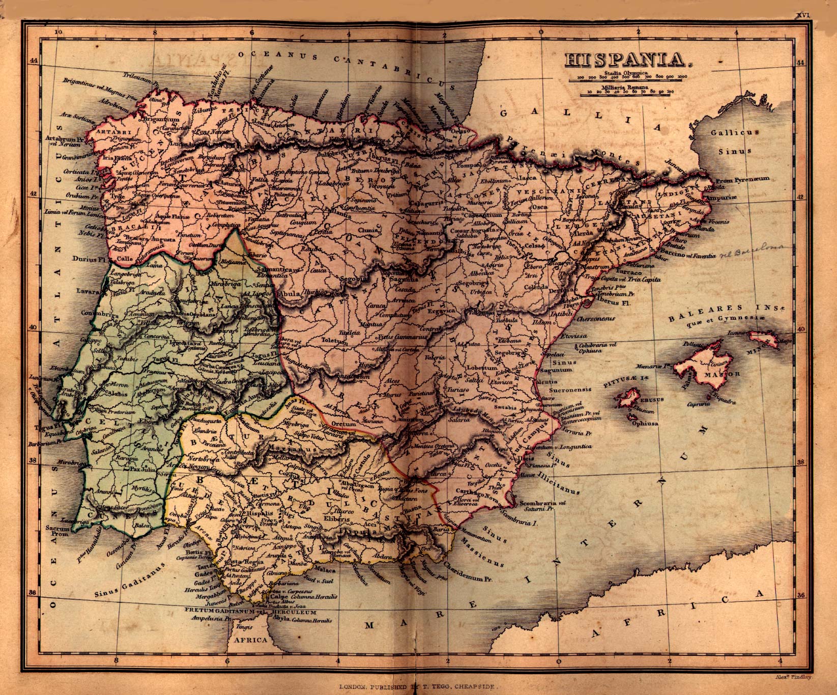
Hispania, from Findlay’s 1849 Atlas
What we were missing (which we often found ourselves consulting as graduate students) were 19th-century productions such as Findlay’s Atlas (see the PDF here), or Butler’s Atlas (here at Project Gutenberg), which married visual consistency, clarity, and topographic detail. Above all, we worshipped the achievement of Carl Müller, responsible for much of the research and production behind many of the maps for Smith and Grove’s Atlas of Ancient Geography published by Murray in 1874. (Richard Talbert told this story in Imago Mundi in 1994; he also characterized Müller’s “comprehensive vision of the physical and cultural landscape of classical antiquity” in a review article of 1997 [American Journal of Philology 117, p. 323]. Smith and Grove’s original volume, which lost money for John Murray, has now been reprinted.)
These were maps with the uncanny ability to tell you what you wanted to know at a glance (general location, geographic position, political affinities, chronological attributes, key relationships to other major features or sites), and which helped to clarify your next questions, rather than leaving you frustrated at minimalist cartography. They were also works of art in themselves.
Reasons for the ‘death of classical mapmaking’ between the 1950s-1990s included a reaction, by the New Archaeology (‘Processualism‘), against a Cultural-Historical Archaeology that sometimes reduced the ancient world to a series of neat ‘period maps’ in which one seemed to be able to track the ‘spread of civilization/empires’ from one part of the globe to another. That justifiable response to over-simplification was abetted, in the 1980s, by a nascent shift to digital publishing processes that for a while made it overly difficult or expensive to reproduce large, high-quality, detailed color maps. Ultimately it was technology that came to the rescue, in the mid 1990s, of the problem it had help cause, with the maturation of GIS (Geographic Information Systems), detailed satellite and digital image processing capabilities, and cheaper, better color printing.
So it was a timely challenge that Richard Talbert and the Ancient World Mapping Center undertook in the 1990s (as he describes in the Preface to both the printed and iPad versions). The need was longstanding, the technology was ready, and the expertise and will had been gathered. The result was certainly a success; the Barrington Atlas is now the standard general map reference in the field. (For a contemporary review of its strengths, weaknesses and potential, see S.E. Alcock, et al., Journal of Roman Archaeology 14 [2001].)
* * *
In an age of increasingly instant and portable knowledge, however, the Barrington Atlas had a problem — at 12.8 x 18 inches in size (necessary for the cartographic detail) and just over eight pounds in weight (necessary for the broad geographic coverage), it was not easily moved. Furthermore, its printed price approaches $400, which means that it is generally affordable only by libraries, which in turn due to its size and cost will understandably not tend to lend it out, but keep it in the reference collection.
These days there is a general unwillingness to pay much of anything for the production and dissemination of knowledge (which has led to a revolt against corporate ‘content providers’ while at the same time undercutting support for the academics expected to do the work). So the Barrington Atlas App, which addresses all the shortcomings of the printed version, is about 1/20 the cost. That still puts it at a ‘premium’ price point in the App Store, which may be wise, since it genuinely has quality, enduring content to offer. While it is unclear whether Princeton will get its money back from the digital production, the App certainly ought to extend and expand the life of the Barrington Atlas project.
So what particular features does the App offer, and how are they implemented? Finally, what opportunities have been missed on this new platform, and how might a digital ancient atlas become more powerful and empowering?
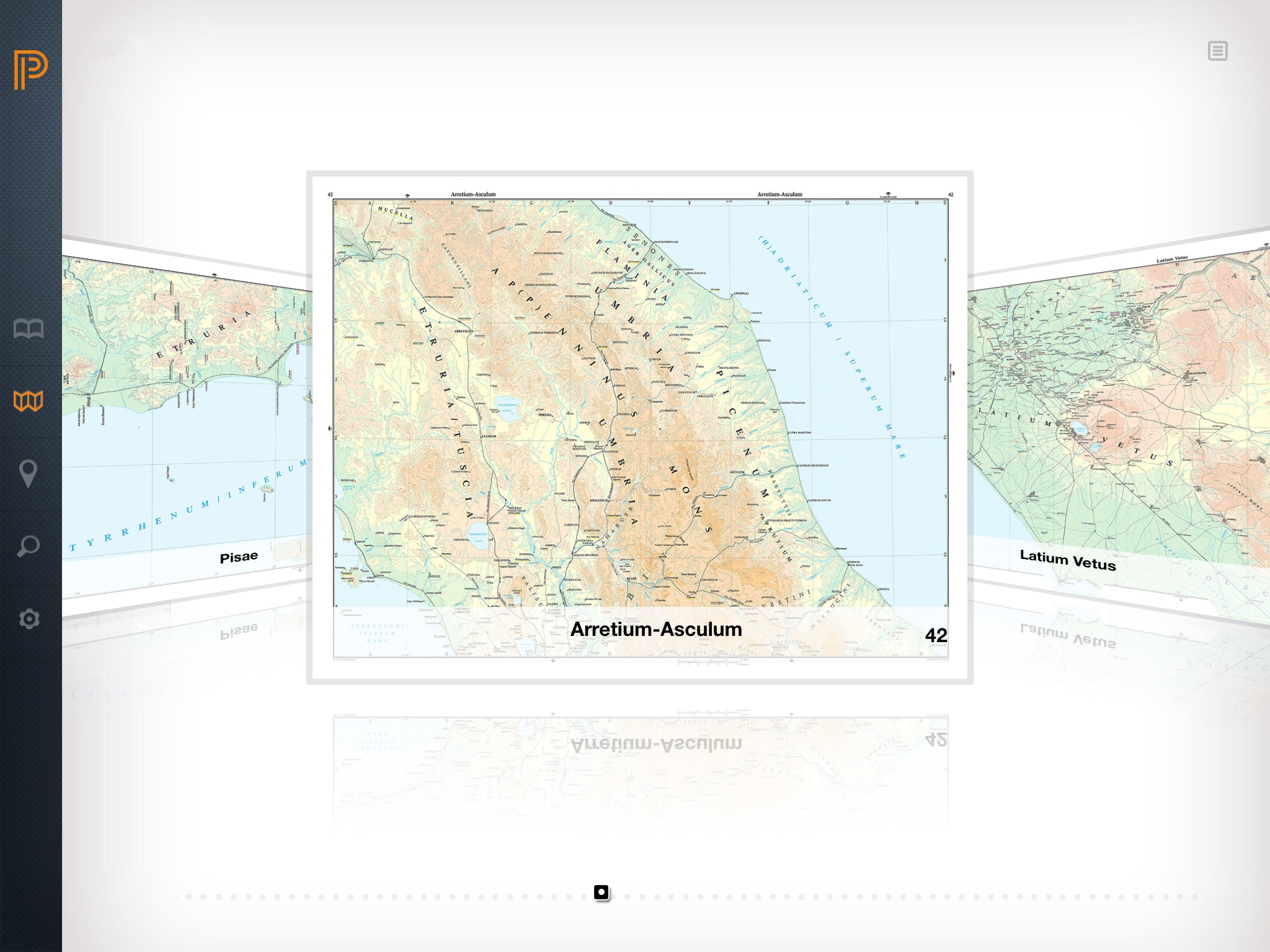
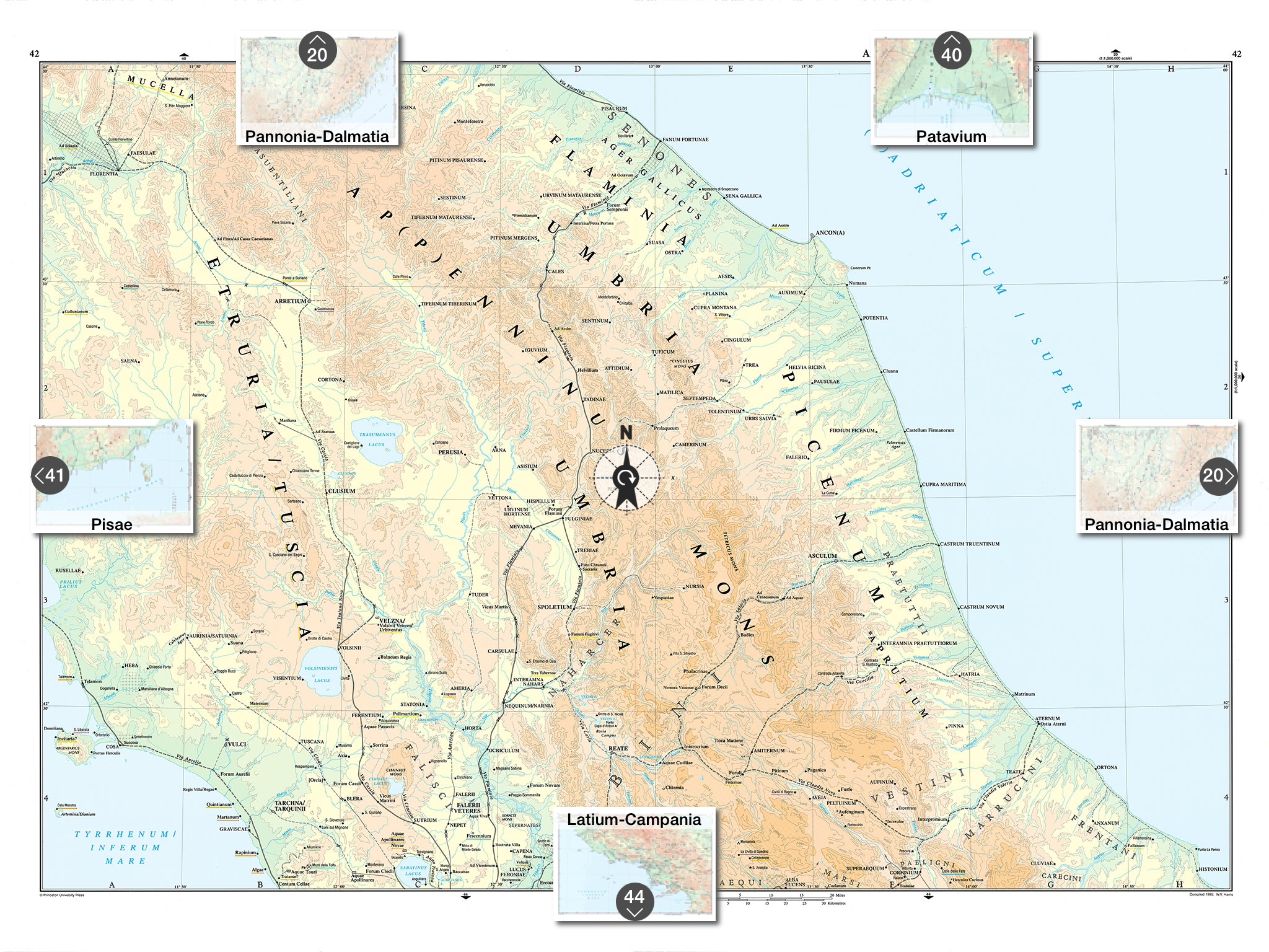
Maps browser
- 1:5 million scale (for supra-regional swaths of territory;
- 1:1 million scale (for areas which might broadly be construed as ‘peripheral’);
- 1:500,000 scale (for ‘core’ areas of the ancient world: North Africa, Itsly, Greece, Anatolia, the Levant, and Egypt);
- 1:150,000 scale (for the urban hinterlands of Rome, Athens, and Byzantium/Constantinople).

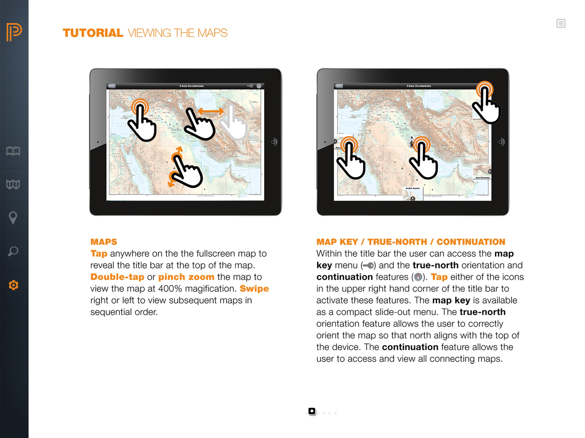
Integrated map key
These maps are presented exactly as they are in the printed text, with a few enhancements. A tap on the screen reveals a top menu with icons of a key and a compass. The key opens a hierarchical map key for chronological designations, cultural and natural feature categories, printed type styles, orthographic conventions for sourcing ancient names, and scale and elevation conventions. This key shows a digital advantage over the paper version, offering quicker access to important metadata conventions. The key slides out at right, covering part of the map, but the map can be moved (at least as long as it is zoomed in slightly) so that a feature or typeface can be compared directly with the key.
Compass function

Locator page
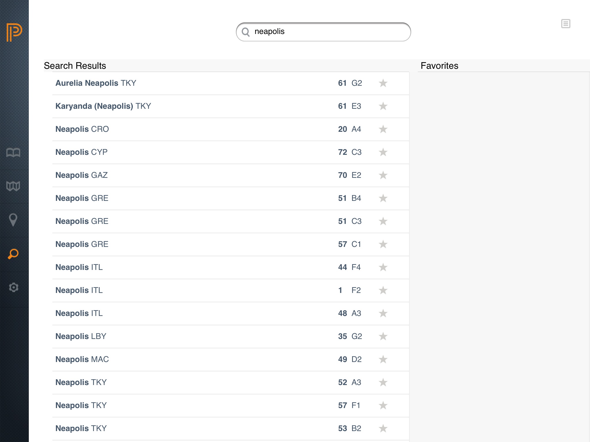
Gazetteer
Help, page 2
- An ancient atlas app should use the built-in GPS so that you can use it to navigate. This means the maps have to be not just detailed images, but generated dynamically by a GIS. It should essentially be a single map, moveable and zoomable to a much higher degree that a series of static snapshots. (Using the GPS is not practical in the current Barrington Atlas App because the scale of the maps is too small to capture meaningful individual movement.)
- An ancient atlas app GIS should offer layers beyond the ancient mapped landscape present in the Barrington Atlas: satellite imagery, detailed topographic contours, and modern roads and infrastructure (all of which are already available).
- An ancient atlas app should permit pre-loading of significant chunks of layers and landscape so that one doesn’t have to drain the mobile network budget on the fly. (The Barrington Atlas App does have this benefit; it loads in its entirety onto the device.)
- An ancient atlas app should permit users to submit corrections to the locations of ancient places and features through ground-truthing.
- An ancient atlas app should be able to access the iPad’s camera, and allow one to embed photos or short videos on-site.
- An ancient atlas app should be able to record basic information about a particular place (limited database capability) which could then be uploaded to an open-source cloud where users could mix/match and then re-download appended or expanded data to the app.
Imagine the power such a research and teaching tool would have. Geographic literacy for students and the general public, in a highly global, highly mobile world, has never been more important. The Barrington Atlas App is the last analog stone in a very old, very long cartographic path. It is wonderful for what it is (and to be fair, it does not claim to be anything else). We should be grateful for the editors’ accomplishment.
And now it is time to dream, and build, much bigger.

Over at http://www.runningreality.org we’re showing changing national borders, city growth, battles, armies, ships, battles, etc over time from 3000BC to today — literally any day in history. We’re a small project team, but as we get data filled in it shows the growth and evolution of human civilization. We’re working on doing dynamic city maps now. We can’t match Google Maps for today’s cities, but we do much better for 1800AD, 800AD, or 800BC! We’ve done a bit of work on Rome, London, Istanbul, and Washington, DC. Our ancient Rome data is not as good as the Barrington Atlas, but we don’t just cover one place and time in history.